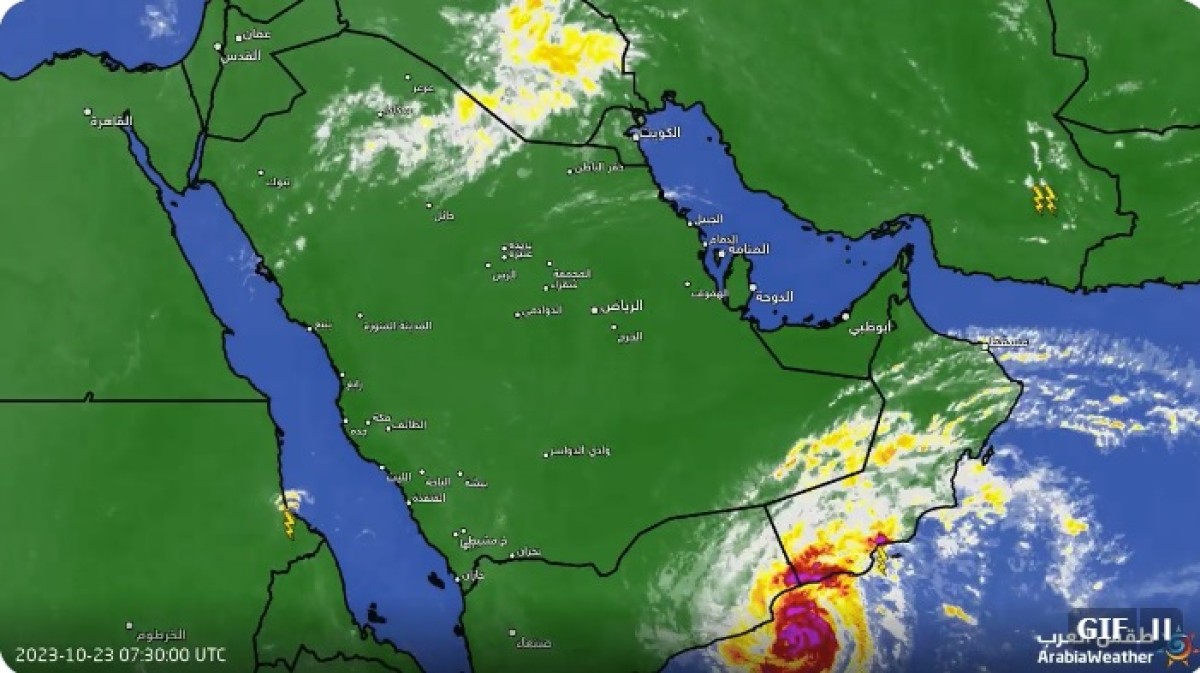
Statement on developments in the tropical situation in the Arabian Sea and its expected effects on Hadramaut and Al-Mahra during the 48th


The Early Warning Center in Hadhramaut Governorate issued a warning bulletin No. (2) regarding developments in the tropical situation in the Arabian Sea
According to the center’s statement, the eye of the hurricane is expected to pass through the area between Nishtun and Haswain in Al-Mahra Governorate from 1:00 p.m. (4 to 7) from the afternoon and evening of Monday to Tuesday dawn, accompanied by intense rainfall, strong winds, and rough sea waves ranging from 5 to 8 meters, with sea tides over low-lying coastal areas.
The following is the text of the statement:
In the name of God, the Most Gracious, the Most Merciful
The latest numerical forecast data issued by the Center and weather map analyzes indicate the continued movement of the tropical cyclone, which is classified as a (second) category, in the eastern territorial waters of our country, with central wind gusts ranging between (85 - 90) knots away from the nearest point of the coast of Al-Mahra Governorate. (35) kilometers, the center of the eye of the hurricane is expected to pass in the area between Nishtun and Haswain in Al-Mahra Governorate from (4 to 7) from the afternoon and evening of Monday to Tuesday dawn, accompanied by intensifying rainfall with strong winds and rough sea waves ranging between 5 to 8 meters with high tides. Marine on low-lying coastal areas.
It is expected that the intensity of the tropical cyclone will decline after crossing the land into a tropical storm and then into a tropical depression within the next (48) hours, moving in a westward direction towards the eastern regions of Hadhramaut Governorate. The indirect effects will begin to a less severe degree and include the coastal strip from Tuesday evening, corresponding to 10/24/2023 AD until Wednesday evening, 10/25/2023 AD.
Therefore, the Center warns all fellow citizens in Al-Mahra Governorate and the eastern regions of Hadhramaut Governorate:-
- Take the utmost caution before the effects of the tropical condition and its accompanying heavy rainfall and increased wind speeds begin to affect the coastal areas and territorial waters of our country. .
- Stay away from the depths of the valleys and do not risk crossing them if they are flowing as a result of the expected torrential floods.
- Ensure that public and private property and vehicles are removed from the valley streams and their branches extending inside cities and villages.
- Avoid touching lighting poles or electrical conductors during and after rain.
- Stay away from flying objects and muddy and dilapidated houses during strong winds and heavy rainfall.
- Be careful not to travel between regions and districts exposed to direct or indirect impacts as a result of the expected flow of valleys and the interruption of roads with low horizontal visibility.
- Take caution for those living near mountain slopes and highlands about the danger of mud and rock slides.
- It also warns: fishermen and seafarers to avoid traveling or sailing due to strong winds and severe sea waves turbulence.
And God Almighty knows best
Issued by: Early Warning of Disasters and Multiple Climate Hazards